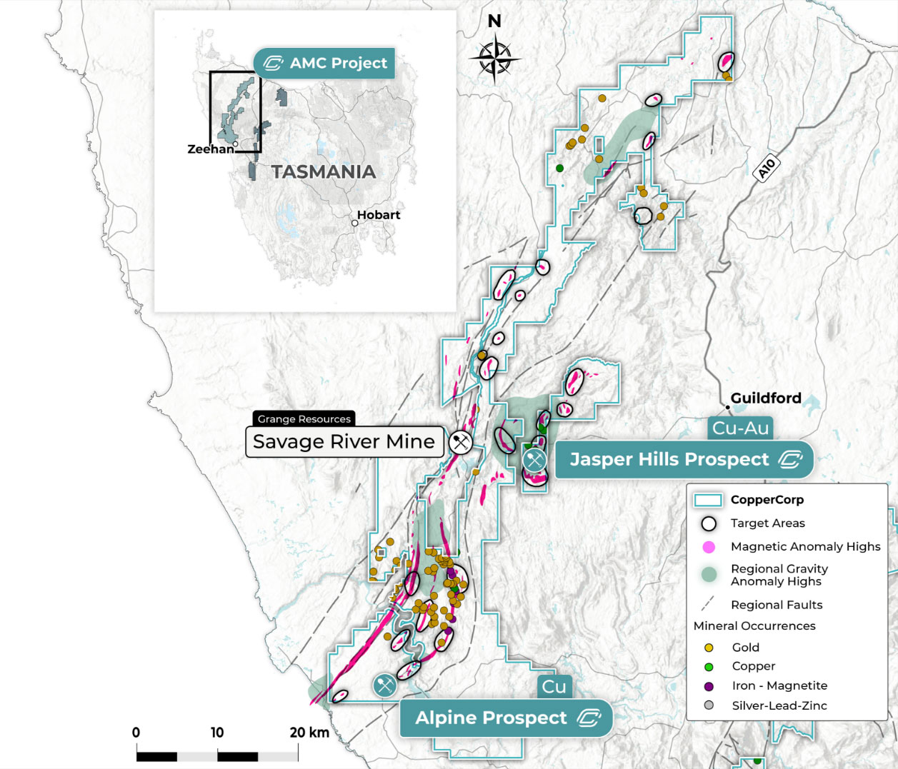
Projects

A Dominant Land Package in a Tier 1 Mining Jurisdiction – Tasmania, Australia

Skyline Project

At the Skyline Project, CopperCorp is targeting an under-explored, district-scale magmatic-hydrothermal IOCG and hybrid porphyry system related to the emplacement of granitoid and porphyry intrusives along the eastern margin of the Mount Read Volcanics (MRV) belt. CopperCorp has recognized that the regional tectonic setting, host rock sequences, and styles of IOCG style mineralization of the MRV belt can be broadly compared with the Andean Coastal Cordillera IOCG belt which hosts numerous large IOCG deposits such as Candelaria (470Mt @ 0.95% Cu, 0.22g/t Au) and Mantoverde (400Mt @ 0.52% Cu, 0.11g/t Au), and the hybrid IOCG-porphyry Productura deposit (236.6 Mt @ 0.48% Cu, 0.1g/t Au).

The Skyline Project has been expanded to include the newly granted Razorback prospect as well as the existing Walford Peak and High Tor properties covers a combined area of 504km², giving the company a dominant land position covering 80km of combined strike length over the eastern margin of the highly mineralized Cambrian-aged MRV belt and its northern correlates. CopperCorp considers the project area to be highly prospective for iron oxide-copper-gold (IOCG) and rare earth element (REE) deposits.

Four large-scale mines occur within 10km of the properties now comprising the consolidated Skyline Project – including the Tier 1 Mount Lyell Cu-Au deposit (3 Mt contained Cu and 3 Moz contained Au @ 1.0% Cu and 0.3g/t Au), the world class Rosebery and Hellyer polymetallic VMS deposits, and the Henty Au deposit (1.64 Moz Au @ 12.5 g/t Au).

Razorback Prospect

The Razorback prospect covers 171km² of highly prospective ground situated directly south of the Mt Lyell copper project. CopperCorp has identified three high-priority exploration target areas as well as other lower priority areas within the Razorback prospect. The high-priority Jukes, Hyde and Darwin zone target areas will be the focus of initial exploration efforts in late 2023.

Darwin Zone

The Darwin zone target, located in the southern portion of the license is defined by a 7km long north-south trending coincident magnetic and potassium-thorium radiometric anomaly. Previous drilling into part of this extensive anomaly at the South Darwin prospect intercepted significant IOCG style Cu-Au and REE mineralization associated with north-south trending hydrothermal breccias comprised of magnetite-hematite-pyrite-chalcopyrite-bornite mineralization hosted in intensely K-feldspar-chlorite-tourmaline altered volcanics directly adjacent to intrusive granites and porphyry bodies. The mineralization at South Darwin remains open at depth and along strike, and with the previous drilling testing less than 10% of the 7km-long anomaly, the company considers there to be excellent further Cu-Au and REE discovery potential at Darwin.

The IOCG style mineralization drilled at South Darwin comprises vein, breccia and semi-massive to massive magnetite-pyrite-chalcopyrite. The previous drilling returned a best intercept of 13.0m @ 1.2% Cu and 0.45g/t Au from 345m (SDD005). Drill hole SDD005 also intercepted significant rare earth element and scandium mineralization, including an intercept of 30.0m @ 2.1% TREO and 73ppm Sc from 297m, including 5.0m @ 3.3% TREO and 98ppm Sc from 311m (Table 1).  There are indications that the Cu-Au and REE grades are increasing with depth at South Darwin and the company is currently planning to drill test this concept in the coming months ahead.

Historical drill assays indicate that the REE mineralization at South Darwin is enriched in critical listed and valuable REE minerals. Approximately 25% of the total rare earth oxide suite in hole SDD005 comprises higher value REE. The grade of high value REE in this hole is 0.53% MREO.

Further potential for REE mineralization in the South Darwin area is indicated by historical surface rock chip sampling assay, with up to 16.2% TREO recorded. Much of the northern part of the Darwin Zone trend remains untested for REEs, however, extensive areas of thorium anomalism in radiometric data indicates good potential for further REE mineralization to be defined.

Table 1. Rare earth oxide values from significant drill hole intercept in SDD005 30.0m @ 2.1% TREO (1.0% TREO cut-off). Values have been rounded. Magnet Rare Earth Oxides (MREO) are shaded

Cross section showing historical drill holes SDD004 and SDD005, South Darwin prospect, Razorback prospect.
Photo of drill core from SDD005 (352.7m), showing IOCG style magnetite-pyrite-chalcopyrite mineralization (352-353m: 0.55% Cu and 0.3g/t Au).
Photo of drill core from SDD005 (353.5m), showing high-grade IOCG style pyrite-chalcopyrite-bornite-magnetite mineralization (353-354m: 1.3% Cu, 0.49g/t Au).

Hyde Zone

The Hyde Zone is located 2.5km north along strike of the Darwin Zone and is interpreted to represent a continuation of the Darwin Zone trend, with the intervening section being covered by overlying rock sequences. The main target area at Hyde Zone comprises a 1.5km long magnetic, radiometric and gravity high anomaly that is interpreted to be indicative of possible IOCG mineralization.  While the target area remains historically untested, extensive areas of outcropping chlorite-sericite alteration with disseminated and stringer vein pyrite-chalcopyrite mineralization flank the western and eastern sides of the magnetic-radiometric-gravity anomaly with surface rock chip sampling in the 1970’s returning assays including 0.5 to 1.25% Cu over 24m, and up to 6.1% Cu and 3.9g/t Au from outcropping gossan.

Jukes Zone

At the Jukes zone area, located 10km south of the Mt Lyell copper mine, historical small-scale mining during the early 1900’s was carried out on high-grade copper-gold magnetite-sulphide pipes with several exploration adits and shafts developed throughout the general area.

The IOCG style mineralization at Jukes is hosted in a zone of K-feldspar-magnetite alteration which is overprinted by a later mineralization phase chlorite-magnetite-pyrite-chalcopyrite event and an outermost zone of sericite-chlorite alteration extending vertically and laterally away from an intrusive granite source situated approximately 1km below surface.

Drilling below historical workings at Jukes in the 1970’s gave a best intercept of 13.4m @ 1.6% Cu and 1.6g/t Au from 61.6m (drillhole JP02) and channel sampling of historical adits returned further high-grade results including 16m @ 1.7% Cu and 1.4 g/t Au, 9m @ 1.55% Cu and 1.56 g/t Au and 2m @ 5.68% Cu and 5.8 g/t Au.  No further drilling has been carried out despite extensive surface exploration identifying broad alteration zones and outcropping mineralization with coincident anomalous magnetics and IP chargeability features extending northwards from the area of historical mining and drilling.

Walford Peak Property

Walford Peak covers 97 km² of prospective ground situated approximately 6km along strike to the north of the Razorback property and within 5km of two large-scale mines – the Mt Lyell Cu-Au project, and the Henty Au deposit. The property contains 5 priority target zones – the Dora, Selina, Linda, Beatrice and Sedgwick Zones, which have been disclosed in previous CopperCorp press releases

CopperCorp recently reported results from its maiden drill program at the Dora prospect which included 29.0m @ 0.18 % Cu from 248m, including 4.0m @ 0.46% Cu and 0.12g/t Au and 31.4g/t Ag from 249m in drillholes D3-001 and 34.0m @ 0.12% Cu from 212m in hole D3-002.

The alteration types and mineralization styles in the Dora drill holes are consistent with those observed with IOCG mineralization at the Razorback property and further review and exploration is warranted at Dora and the other priority target areas at Walford Peak.

High Tor Property

The High Tor property covers 237 km² of ground situated approximately 5km along strike to the northeast of the Walford Peak property and within 4km of the world-class Hellyer VMS deposit. The property is considered prospective primarily for IOCG style mineralization, being a northern continuation of the Razorback – Walford Peak IOCG system.  Preliminary review work by CopperCorp has identified a high-priority IOCG style target at the Ten Mile Creek prospect where extensive hematite-sericite alteration, stockwork hematite veining and hematite matrix breccia occurs over a zone at least 2km in strike length and 50-100m wide and is spatially associated with magnetic and gravity high features and anomalous copper and gold geochemistry. Peak gold assays up to 8g/t Au have been returned from surface sampling, while up to 0.52g/t Au has been returned from shallow drilling (<50m) into hematite stockwork mineralization at Ten Mile Creek.

Photo of drill core from Ten Mile Creek prospect hole TMC4 showing hematite matrix breccia developed in porphyritic granitoid host rock.

AMC Project

The AMC Project, spanning 1,066 km², establishes CopperCorp as a dominant owner of prospective ground in the district. The project area contains rocks of Neoproterozoic-Cambrian age, hosting magnetite-sulphide-silicate alteration and mineralization indicative of a large Iron Oxide Copper Gold (IOCG)-style system. The Alpine prospect, located within 30 km of Zeehan, boasts two large-scale operating renewable energy plants nearby.

Alpine Prospect

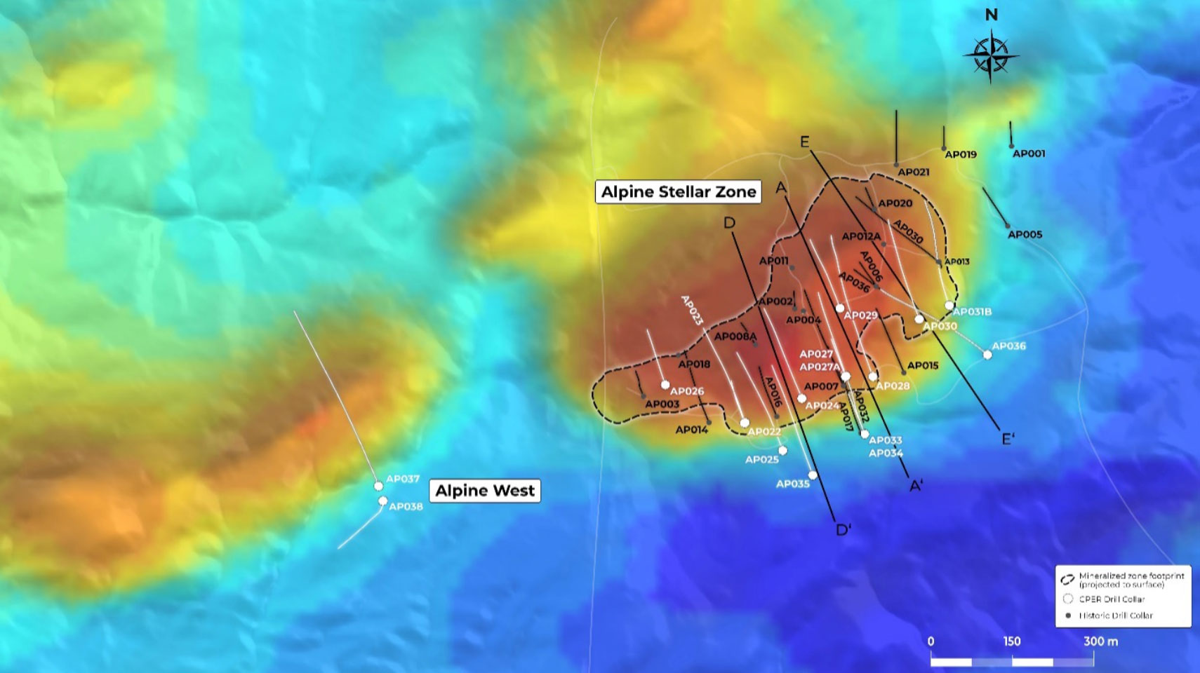
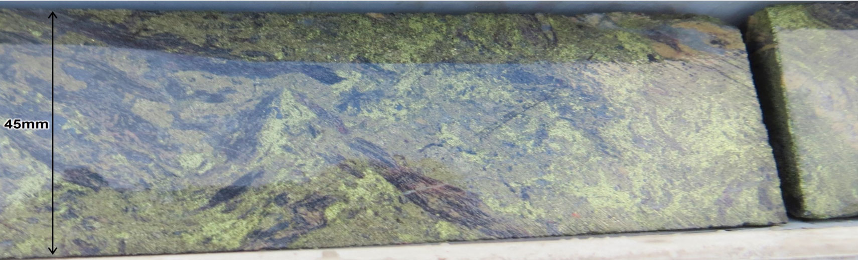
CopperCorp’s maiden drill program at Alpine focused on infill, extension, and step-out drilling to target thicker and higher-grade mineralization zones. To date, 17 holes have been completed, with notable intercepts of copper mineralization reported (see news section). The high-grade copper zones at the Alpine Stellar zone are associated with chalcopyrite mineralization in structurally controlled breccia zones and fracture vein networks. The company is conducting a geological review to refine the Alpine geological model for future drilling.

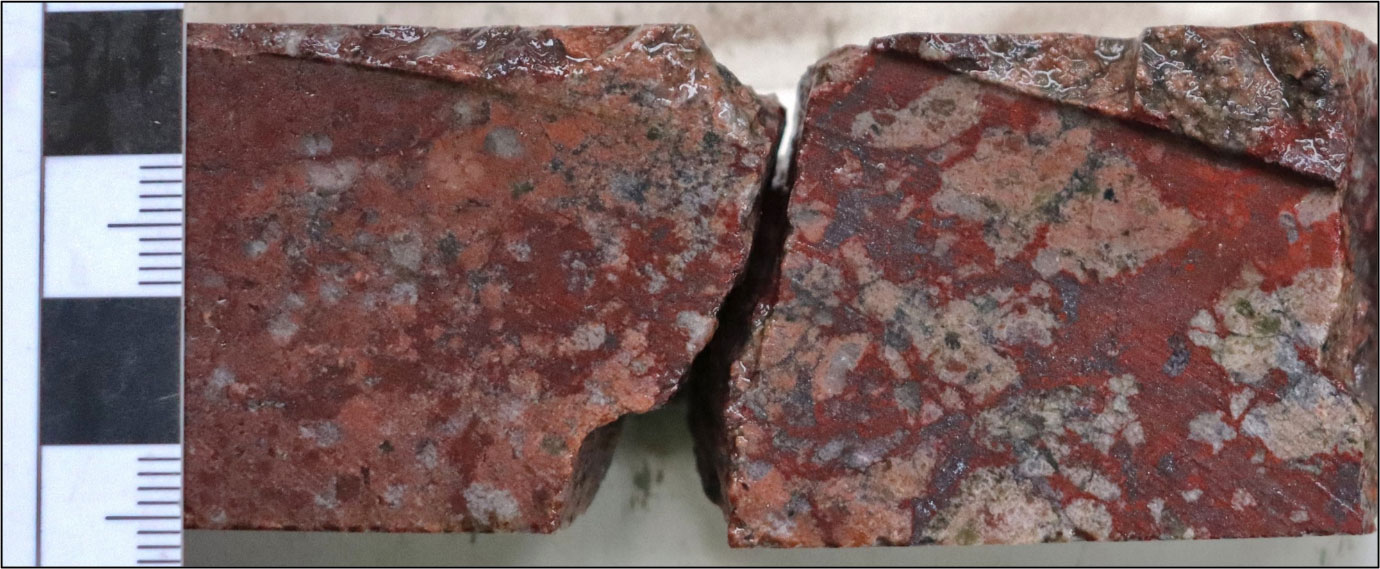
The Alpine prospect was discovered in the 1980s and saw historical drilling that intersected significant IOCG-style copper mineralization. The mineralization at Alpine is hosted in deformed and metamorphosed rocks, primarily amphibolites, mafic and pelitic schists, graphitic phyllites, and carbonates. Copper mineralization is associated with magnetite-hematite-siderite-sulphide lenses and chalcopyrite-pyrite breccia, vein, and disseminated mineralization.

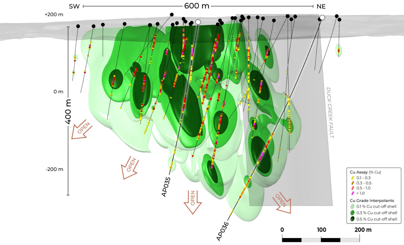
The mineralization strikes east-northeast and dips steeply to the southeast, forming a fault-bound boudinage over 600m in strike length. The deposit remains open down dip and along strike to the west. Geophysical modeling indicates the presence of IOCG-style mineralization defined by coincident gravity and magnetic anomalies. The model also suggests additional areas of high IOCG prospectivity, including the Alpine West and Alpine North targets.

1st vertical derivative magnetics greyscale image with colour gravity inversion model 250m depth slice image overlay

Drilling Highlights

  • AP004: 28.2m @ 1.03% Cu from 58.7m (within 38.2m @ 0.79% Cu from 57.7m).
  • AP030: 10.0m @ 1.20% Cu from 185.0m (within 37.0m @ 0.57% Cu from 181.0m).
  • AP030: 4.9m @ 1.50% Cu from 3121m (within 18.0m @ 0.70% Cu from 307.0m).
  • AP034: 5.0m @ 2.06% Cu from 187.0m (within 31.6m @ 0.64% Cu from 177.7m).
  • AP035: 18.0m @ 0.90% Cu from 238m (within 45.0m @ 0.62% Cu from 217.0m).
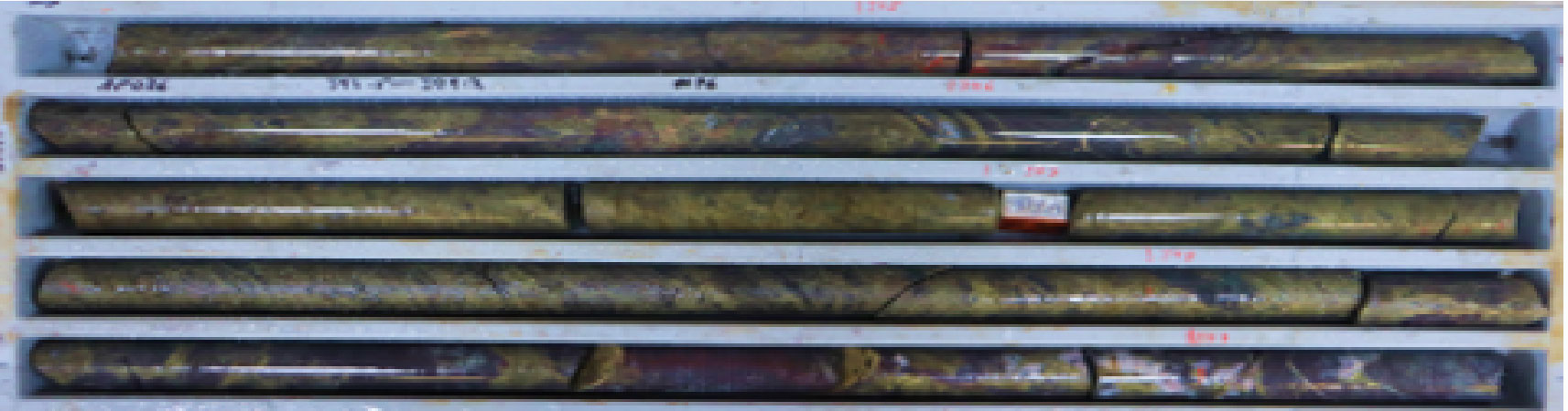
  • AP036: 23.0m @ 1.14% Cu from 393m (within 92.0m @ 0.50% Cu from 334.0m).

AP036 high-grade Cu mineralization (tray interval averaged 1.4% Cu) within: 23m @ 1.14% Cu from 393m (within wider zone: 92m @ 0.5% Cu from 334m)

AP034 high-grade Cu mineralization (chalcopyrite) in 1m interval (189-190m) grading 3.1% Cu within: 5m @ 2.06% Cu from 187m (within wider zone: 31.6m @ 0.64% Cu from 177.7m)

Alpine Stellar Zone

Strategy to expand mineralized footprint:

  • Confirmed mineralization over 600m strike and to 400m depth below surface (OPEN)
  • Drill permitting in process to target high-grade depth extensions
  • Exploration along trend to expand resource footprint

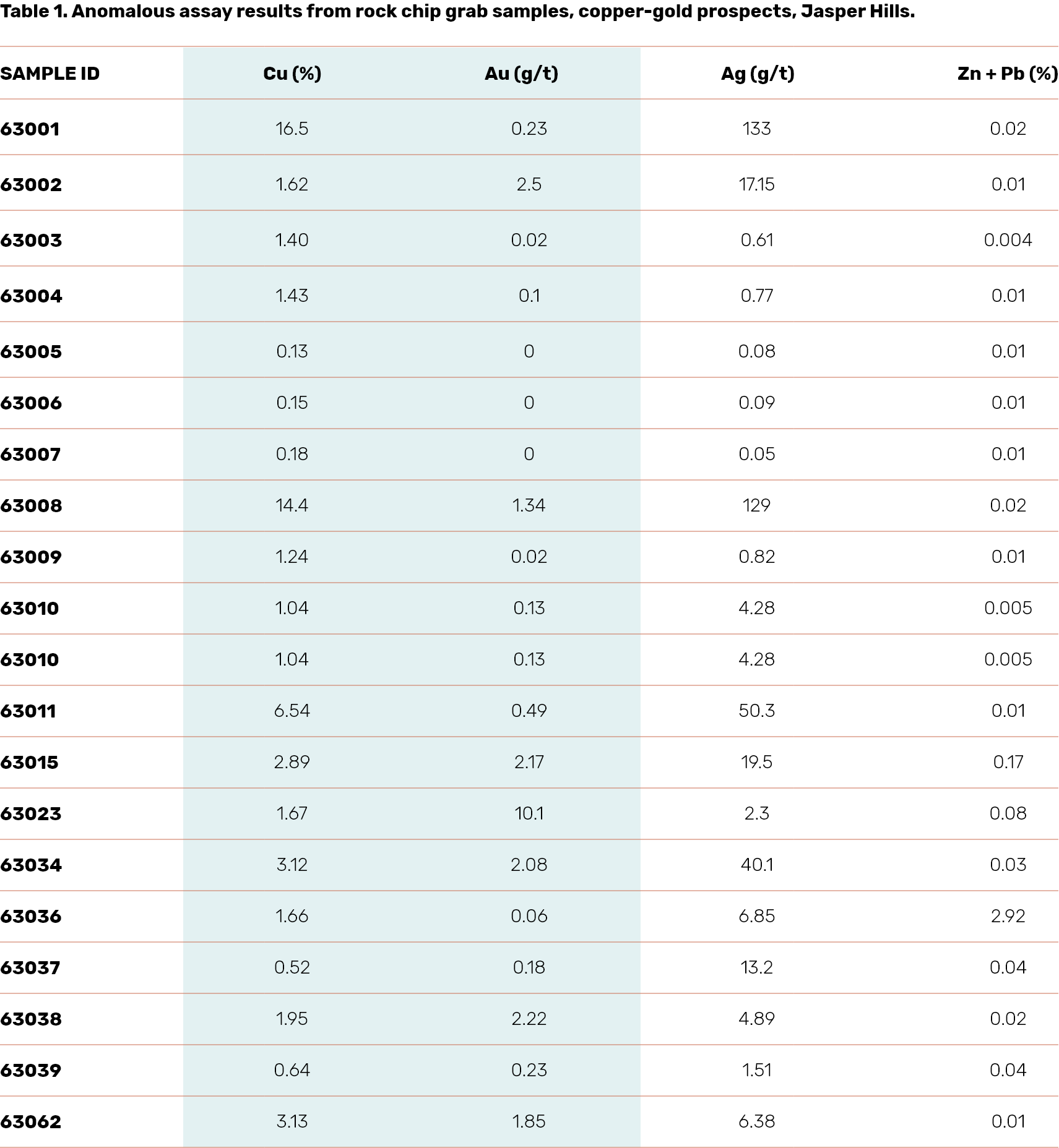
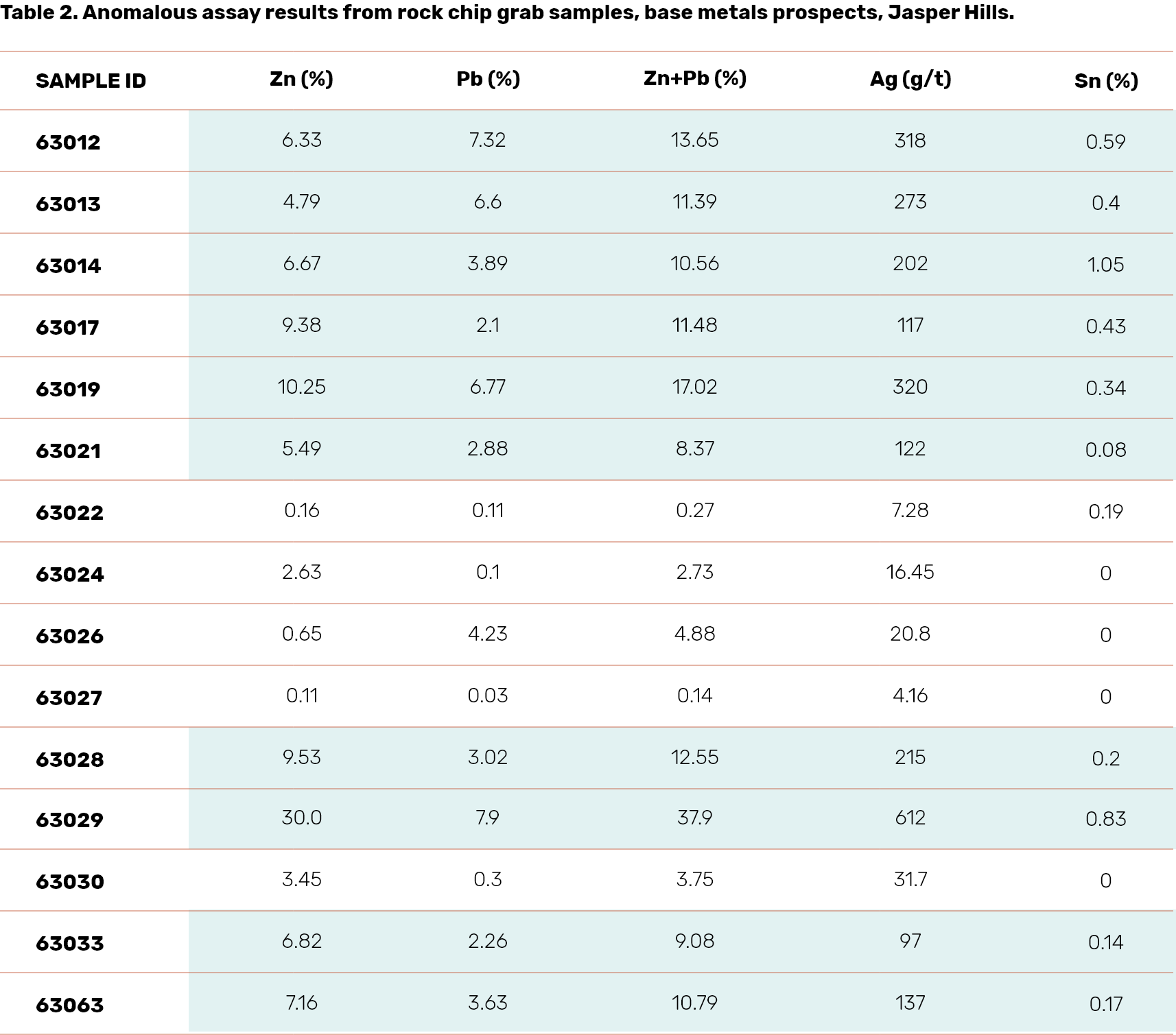
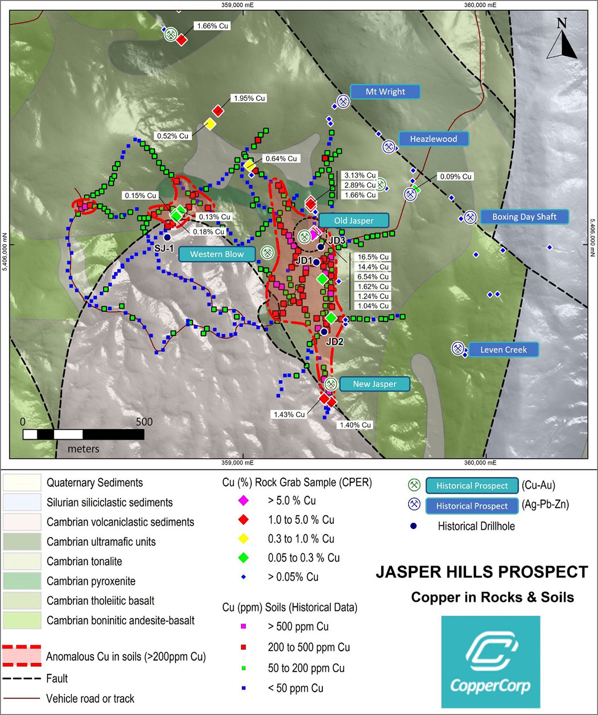
Jasper Hills Prospect

The Jasper Hills prospect is located in Exploration License EL1/2020, about 10km east of Savage River magnetite mine and 35km northeast of CopperCorp’s Alpine prospect. The area is accessible via a sealed road and a network of 4WD tracks, with electrical transmission lines nearby.

The bedrock geology is mainly Cambrian mafic to ultramafic and volcanic-sedimentary sequences, with some Ordovician to Silurian, Tertiary, and Quaternary sediments, as well as Devonian-aged Meredith granite in the south.

Historically, mining began in the 1880s for silver, then copper after the discovery of outcropping copper mineralization around 1898. Small-scale mining was mainly for near-surface high-grade oxide lodes at Old and New Jasper mines until about 1920. Limited records indicate approximately 200 tons of copper ore and concentrates with about 20% Cu and 6g/t Au were produced. Additionally, around 300 tons of lead-silver-zinc ore were extracted from the Mt Wright-Heazlewood mines.

The copper-gold mineralization at Jasper Hills is found in veins and disseminated in altered basalt, pyroxenite, and sedimentary rocks. It is believed to be of Cambrian age and of primary magmatic/volcanogenic origin, possibly later remobilized during Devonian granite intrusion events.

Silver-lead-zinc prospects occur in a northwest-trending structural zone in altered mafic ultramafic rocks. These mineralized vein lodes are 1-5m wide, and were historically mined for high-grade silver. No drilling tests have been conducted on these prospects.

Tin mineralization wasn’t recognized in the area, but nearby significant tin mines exist.

Several companies have conducted exploration activities since the 1960s, but much of it was superficial. Limited historical drilling included 14 shallow RC holes and 4 diamond core holes between 1988 and 2013. Results were inconclusive due to various issues including drilling difficulties and not reaching target depths.

Multiple geophysical surveys have been performed and the Company is reviewing available open-source data.

16.15% Cu, 0.23 g/t Au – Jasper Hills

30.0% Zn, 7.9% Pb, 612 g/t Ag